15 de juny 2014

(Tri-point) Border between Austria, Czech Republic and Germany

English: The Bohemian Forest, known in Czech as Šumava, is a low mountain range in Central Europe. Geographically, the mountains extend from South Bohemia in the Czech Republic to Austria and Bavaria in Germany. They create a natural border between the Czech Republic on one side and Germany and Austria on the other.


Spanish: El Bosque de Bohemia, conocido en checo como Šumava, es una sierra de montañas bajas en Europa Central. Geográficamente, las montañas se extienden desde el sur de Bohemia en la República Checa a Austria y Baviera en Alemania. Crean una frontera natural entre la República Checa, por un lado, y Alemania y Austria en el otro.


English: In the Czech Republic, the most valuable area is protected in the Šumava National Park and Protected Landscape and the UNESCO Biosphere Reserve. Part of the German section is protected as the Bavarian Forest National Park. The Bohemian Forest is a popular holiday destination because it is excellent hiking country. Most interesting natural and cultural sights are connected with more than 500 km of summer marked trails and many bike trails. However, park administration is not always successful in its task, and many believe the rapid growth of tourist accommodation and services is destroying the former calm of the Šumava region. Šumava National Park is also suffering problems connected with bark beetles (trees are dying), and there is heated debate about how to deal with it.

Spanish: En la República Checa, el área más valiosa está protegida en el Parque Nacional de Šumava y Paisaje Protegido y la Reserva de la Biosfera por la UNESCO. Parte de la sección Alemana está protegida como Parque Nacional del Bosque de Baviera. El Bosque de Bohemia es un destino turístico muy popular, ya que es un excelente lugar para pasear. Paisajes naturales y culturales más interesantes están relacionados con más de 500 km de verano marcadas Senderos y muchos senderos para bicicletas. Sin embargo, la administración del parque no siempre tiene éxito en su tarea, y muchos creen que el rápido crecimiento de los servicios de alojamiento turístico y está destruyendo la antigua calma de la región de Bohemia. Parque Nacional de Šumava también está sufriendo problemas relacionados con los escarabajos de corteza, y hay un acalorado debate sobre la manera de tratar con él.


11 de juny 2014

Borders between France, Germany and Switzerland

German (Deutsch): Dreiländereck.

English: This is the three border between France, Germany and Switzerland. Is in the river Rhine. The monument is about 50 meters from the exact point at the port of Basel (Switzerland). You can only visit this monument by foot from Switzerland and by boat from anywhere.

Español: Esta es la frontera entre tres paises, Alemania, Francia y Suiza. Bañada por aguas del río Rin (Rhein - Rhin). El monumento esta a 50 metros del punto exacto, en el puerto de Basel (suiza). Este monumento es solamente accesible a pie desde Suiza y en barco desde cualquier otro lugar.


Border between Norwey, Sweden and Finland

Swedish (Svenska): Treriksröset.
Noruegian (Norsk): Treriksrøysa.
Finnish (Suomi): Kolmen Valtakunnan Rajapyykki.


English: This is the three county border between Norwey (Norge), Sweden (Sverige) and Finland (Suomi). 
The tripoint monument itself is a yellow dome-shaped stone made of concrete, located about 10 metres (33 ft) out in Lake Goldajärvi (also known as lake Koltajauri). It is located at 489 metres (1,604 ft) above sea level. The monument was built in 1926. The size is about 14 square metres (150 sq ft) with diameter of about 4 metres (13 ft). It is mentioned as the world's smallest island divided by a border.
It is reached by walking 11 kilometres (6.8 mi) from Kilpisjärvi in Finland on a public road. In summertime, it can be reached by boat from Kilpisjärvi plus a 3 kilometres (1.9 mi) walk.

Spanish: Esta es la frontera entre tres paises, Noruega, Suecia y Finlandia.

El monumento en sí es una piedra en forma de cúpula amarilla de hormigón, aproximadamente a 10 metros en el lago Goldajärvi (también conocido como lago Koltajauri). Esta situado a una altura de 489 metros por encima del nivel del mar. El monumento se construyó en 1926. Tiene un tamaño de 14m2 y un diámetro de 4m. 
Se dice que es la isla más pequeña del mundo dividida por 3 fronteras.
Se puede llegar caminando 11km  desde  un pueblo de Finlandia (Kilpisjärvi). En el verano, se puede llegar en barco, con un trayecto de 3km, des de Kilpisjärvi.


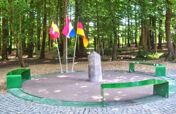
Border between Belgium, Germany and The Netherlands

English: Border between three countries. Belgium, Germany and The Netherlands.
Spanish: Frontera entre tres paises. Bélgica, Alemania y Holanda. 


English: The high point of the Netherlands is clearly marked (321m). In the background you can see the base of an observation tower. That's in Belgium. And those trees to the left - they're in Germany.

Spanish: El punto más alto de Holanda esta marcado en esta estatua (321m). En el fondo de la imágen se puede ver una torre de obersvación. Ésta esta en Bélgica. Los árboles de la izquierda pertenezen a Alemania.